
There is one other image of this object. See our image rights statement.
Object Timeline
|
|
|
1970 |
|
|
2012 |
|
|
2015 |
|
|
2023 |
|
|
2024 |
|
|
2026 |
|
Website, Watercolor Maps
This is a Website. It was designed by Geraldine Sarmiento, Zachary Watson, Eric Rodenbeck, Nathaniel Kelso, Michal Migurski and George Oates and firm: Stamen Design. It is dated 2012-2015. Its medium is web project. It is a part of the Digital department.
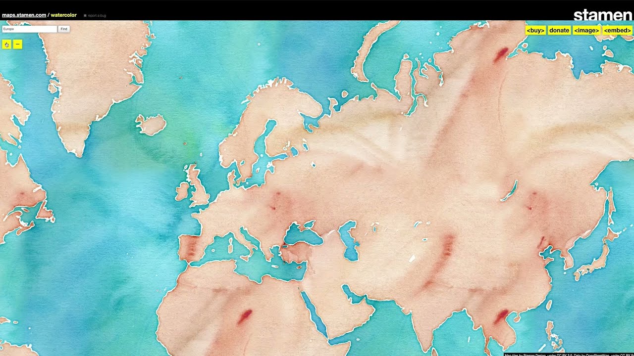
Watercolor Maps is a web-based, open-source mapping tool that redraws OpenStreetMap data with the hand-hewn textures of watercolor paint. It breaks from traditional online cartography by emphasizing aesthetics at the same level as representational accuracy. The marks on the screen are based on real-world data, and the mapmakers have taken liberties with the rendering process to emphasize that the maps are the product of human–computer interaction, not the end result of faceless robotic activity.
In the interactive map website, water is rendered in blues mixed with turquoise and violet; green spaces are yellow, forest and muddy greens; terrain is a combination of peaches, browns and violet; motorways are oranges, reds and browns; buildings are lavender gray. The colors retain the texture of rough paper. A wet-wash technique results in darker tones where the pigment accumulates and disperses in lighter hues.
The aesthetic recaptures the tactility and hand-hewn nature of physical maps, qualities that are often lost with digital maps, while being rooted firmly in the open data ethos and global nature of the OpenStreetMap project. The maps have been ubiquitous on the web and used in thousands of mapping projects around the world.
Cooper Hewitt made a fully-functioning, interactive, and open-source copy of the Watercolor Maps site to ensure its long-term live access, which is located at http://watercolormaps.collection.cooperhewitt.org. This collection record represents the complete work, which consists of three parts: individual image files of the tiles (2021-5-1), Stamen’s original website code (2021-5-2), and Stamen’s code for rendering the tiles (2021-5-3).
When Stamen's site launched in 2012, Stamen's designers authored code (2021-5-3) that applied hand-painted watercolor textures to OpenStreetMap data using algorithmic scripts written in Python. Those tiles were cached as visitors to the site explored the world, up until 2018 when Stamen stopped rendering new tiles. Cooper Hewitt's archived copy of the Stamen tileset (2021-5-1) represents the product of that code, and those tiles are presented in a live website (2021-present) maintained by Smithsonian to allow ongoing access, based on Stamen's original website code (2021-5-2).
This object was
donated by
Stamen Design.
It is credited Gift of Stamen Design in honor of Zachary Watson.

Watercolor Maps by Stamen Design
Stamen founder Eric Rodenbeck is interviewed about Watercolor Maps, a website that displays digital maps rendered as if painted by hand. He is a white man with a long red beard, and medium-long...
This object was previously on display as a part of the exhibition Acquired! Shaping the National Design Collection.